 |
|---|
|
|---|
[recommended screen size: 800x600 pixels]
| A LAND
CALLED
Hessen (with many other maps of Germany) |
|---|
If there ever was a place with changing names and borders, it is Germany. And at the heart of Germany is the modern federal state of Hessen, which is no exception. What follows is an attempt to "lay it all out" for the benefit of family tree researchers around the world. I'll do it with as little text as possible. I want the maps to explain it all, rather than burdening the site with cold narrative. After you have studied this presentation please bring errors to my attention at once, if not sooner! Allow me to express my appreciation up front to two very special people: Karl Schien, who lives in Hessen, and who provided the original black and white maps, and Dona Ritchie, a former Hessen living in the USA, who added color and enhanced fonts. With folks like these in our midst, we have a lot going for us. Thanks, Karl! Thanks, Dona! Awesome!
The modern state of Hessen in Germany was officially created on 16 October
1945 by decree of the occupying U.S. forces of war-torn Germany. The new
Hessen incorporated the provinces of Kurhessen and Nassau, Hessen-Kassel,
and Hessen-Darmstadt, but left out Oberwesterwald, Unterwesterwald, Unterlahn
and St. Goarshausen, which were given to the French occupying forces in
Rheinland-Pfalz, along with Rheinhessen, Bingen, Mainz, Alzey, and Worms.
Only the Christian Church in Germany retained the old geographic boundaries
of Kurhessen, Nassau, Waldeck, Wetzlar, and others in existence before
1945.
Kurhessen (the "electorate" of Hessen under the Holy Roman Empire) included
these districts and provinces in the 1840s:
Niederhessen, with the towns of Kassel, Eschwege, Fritzlar, Hofgeismar,
Homberg, Melsungen, Rotenburg, Schaumburg, Witzenhausen, and Wolfhagen.
Oberhessen, with the towns of Marburg, Frankenberg, Kirchain, and
Ziegenhain.
Fulda, with the towns of Fulda, Hersfeld, Hünfeld, and Schmalkalden.
Hanau, with the towns of Hanau, Gelnhausen, and Schlüchtern.
Today, Kurhessen is known as Hessen-Kassel, although the boundaries are not
exactly the same.
In the 19th Century Wiesbaden, the modern capital of the state of Hessen,
was the capital of the Duchy of Nassau. The Nassau family originated the
so-called "Orange Territory" in France, The Netherlands, Luxemburg, and the
King of England was at one time William of Orange. The Duchy of Nassau lay
northeast of the town of Nassau, along the Rhein River. In 1866 the Duchy
of Nassau became known as Hessen-Nassau. Following World War II, it disappeared,
with the allies determining where borders lay. Hessen-Nassau became partly
in the state of Hessen and part ly in the state of Rheinland-Pfalz. It continues
today only as a designation for the church boundaries in that region, which
have been maintained, much to the confusion of non-German researchers.
One thing is certain: You must know the name of the village, town, or city
in order to make progress with German research. AND you must realize that
many, many villages, towns, and cities in Germany have the same name, AND
that many older villages and towns have been absorbed by the cities, disappearing
forever, except in the hearts and minds of the locals. Remember that unless
you establish that the ancestor you are seeking is in your direct line, you
will probably not survive German privacy laws.
CLICK
HERE and
CLICK
HERE to read more about Hessen. REMEMBER: DON'T GET LOST! Your back button
is your friend!
MAPS!
Historical (Ancient) Maps with Translations
Pre-German
Maps
(Maps before Germany became one Nation. Clickable!)
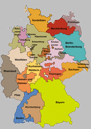
Evangelical Church Districts today follow the original jurisdictional
boundaries prior to 1866, making this modern church boundary map useful for
earlier regional evaluation. This is not a modern political boundary
map.
 |
|---|
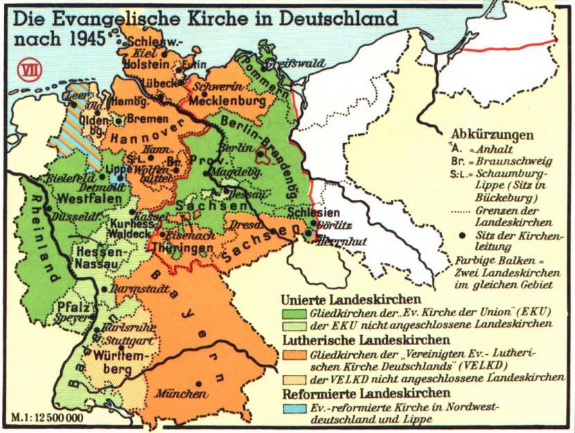
Another View of Evangelical (non-Catholic) church boundaries in Germany as organized after 1945
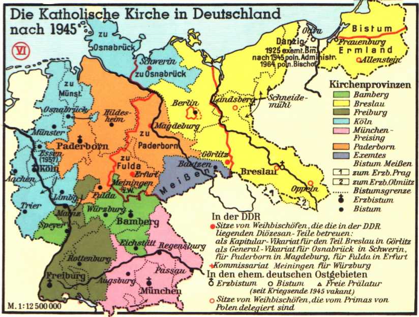
Catholic Church boundaries after 1945
Select from these Maps:
| Historical
History / Maps for German Speakers |
|---|
Historical Maps of Pre-State Germany
Bavaria, Austria, Italy, and the Electorate of Hesse in 1806
Southern
"Germany" 1801-1819
German "States" until
1918
and much, much more!
Maps of the
Past!
(World-Wide, not just Germany)
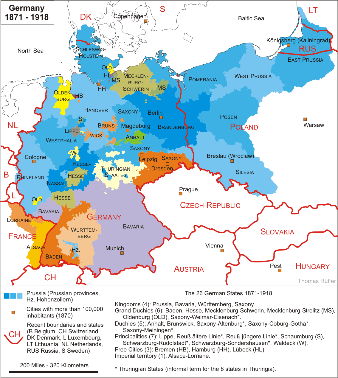
Germany 1871-1918
Includes description of kingdoms, grand duchies
and other configurations in
1914
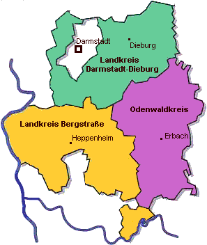
An example of Modern Districts (or counties; Landkreisen); Darmstadt
area.
Click on the map for the State Museum of Hessen
located in Darmstadt.
Eastern Europe Maps
Hessen &
Bordering Entities 18th Century
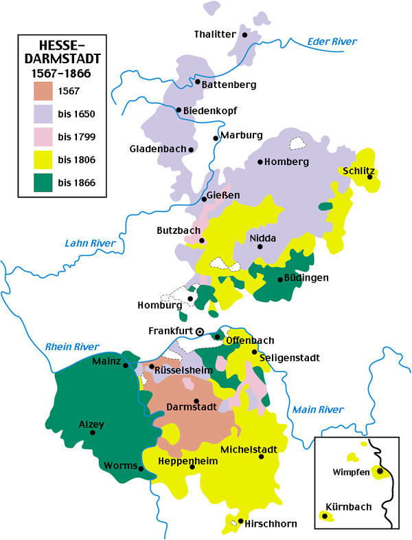
Hessen-Darmstadt
1567-1866
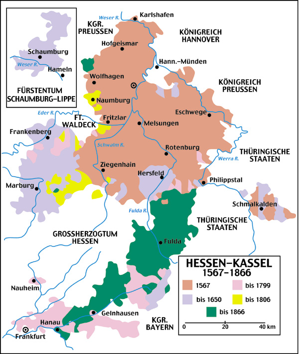
Hessen-Kassel
1567-1866
Hessen-Nassau
and essential German Resources
(don't miss this one!)
Hessen,
1815-1866
Atlas des Deutschen
Reichs
(Downloadable Maps, Adobe Format)
Until 1803 "Germany" was a collection of principalities, dukedoms, tiny states, church-states, and independent villages, towns, and cities. In 1803 Napoleon Bonaparte decided how "Germany" should be configured. He drew the maps, abolished the church-states, and decided how "Germany" would function. In 1815 Napoleon met his "Waterloo," and the reassembly of "Germany" began. There were the duchies of Hessen-Kassel, Hessen-Darmstadt, and the Herzogtum of Nassau. The latter had Wiesbaden for a capitol. In the war between Austria and Prussia in 1866, Hessen-Kassel and Herzogtum Nassau sided with Austria, and lost. They reappear under Prussian rule as one entity, Hessen-Nassau, which also incorporated the free city of Frankfurt am Main. The duchy of Hessen-Darmstadt retained its identity. After World War II the allies created the Federal German State of Hessen, which incorporated the former Herzogtum Nassau and Hessen-Darmstadt, along with Hessen-Kassel. RheinHessen and The Westerwald, formerly part of Hessen, were left out of the mix, becoming part of Rheinland-Pfalz. Hessen-Giessen was created in Hessen in 1990.
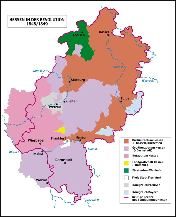
Hessen during the
1848-49 Revolution
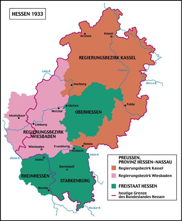
Hessen in 1933
Use your Back Button to return to this page after visiting each of the following
sites:
Country/City Maps
MAPS
- Germany
MAPS
II - Germany
Hessen
(German Language)
Hessen
History
The Wonderful Odenwald (Modern - German Language)
http://www.odenwald.de/sights.htm
Germany
Through
The Ages
Prussian
Maps
German
Empire 1882 - East
German Empire
1882 - East & West
Modern German States (Location)
Federal German States (List)
Hessen
Counties (after 1974)
World
Maps
The David Rumsey Map
Collection
(Intended for highspeed computers with maximum capabilities,
on cable or DSL. Awesome 3-dimensional maps
with overlay possibilities, the dream of every intensely involved historical
researcher.)
Alternate Link
Map
Choices
Historical
Maps with Descriptions
Historical German
Maps
Germany
1618
The Pfalz Divisions
(Maps)
Town Maps,
Rheinland-Pfalz
Index to FEEFHS Historical Maps
Germany 1801-1819
Historical Map
The Territory of Niedersachsen in the 19th Century
THE DIVISIONS
OF THE HOLY ROMAN EMPIRE IN GERMANY
Imperial
Ecclesiastic States
Medieval
Maps of Europe
Free Map Links
East
Prussia
Prussia
Online
Map Access,
Regions
Whence
cometh the Englisch?
30-Years War
1.
Bohemian
Wars
2.
Denmark
Intervenes
Description of Thüringen and the many Sachsens, Courtesy Dieter Taube
I notice, that many american fellow searchers are confused of the
historical geography of Thuringia and the lot of "Saxonies" in German history.
Let me give a short explanation. You must distinguish:
1. The former Kingdom of Saxony (today: Freistaat Sachsen). The most important
towns are Dresden, Leipzig and Chemnitz.
2. The former Province of Saxony. It was a part of Prussia with the big cities
of Magdeburg and Halle. Since 1945 it is united with the former duchy
of Anhalt to the federal state of Sachsen-Anhalt.
3. Lower Saxony (Niedersachsen). Today a German federal state it has less
political or historical roots (it was founded 1946, former states
were Hanover, Brunswick, Oldenburg, Schaumburg- Lippe and parts of
Anhalt and Hessen) but more linguistic and tribal togetherness: All
people speak nearly the same Nether German dialect. These kind of Saxons
in the ancient days were going to conquer England, America and so on ...
4. Some of the Thuringian principalities also weared the name of Saxony,
but they did not belong to one of the upper listed Saxon territories.
The origin of these names is of dynastic traditions. One country - this is
yet more curious - was even called Russia. Prince Heinrich, who dared a long
journey to Russia around 1300, was as delighted of what he must have seen
there, that he thenceforth named his kingdom "Reuß", that's the poetic
name for Russia.
Since1860...70 the Thuringian countries were: Sachsen-Weimar-Eisenach, grand
duchy Sachsen-Koburg-Gotha (Saxe-Coburg-Gotha), duchy Schwarzburg-Sondershausen,
principality Schwarzburg-Rudolstadt, principality Sachsen-Meiningen, duchy
Sachsen-Altenburg, duchy Reuß jüngere Linie, principality
Reuß ältere Linie, principality Some central an northern parts
of Thuringia belonged to Prussia (Province of Saxony, Regierungsbezirk
Erfurt).
TRAVEL GENIE
http://www.travelgenie.com/index.htm